Vietnam National Parks
In 1963, Ho Chi Minh said "the current destruction of our forests will lead to serious effects on climate, productivity and life. The forest is gold. If we know how to conserve and manage it well, it will be very valuable." Unfortunately, the war and slash-and-burn farming would lead to large scale destruction of Vietnam's forests. However, it is still a country uncommonly rich in plants, animals, and natural habitats, the Socialist Republic of Vietnam shelters a significant portion of the world's biological diversity, including rare and unique organisms and an unusual mixture of tropical and temperate species.
Paradoxically, as Vietnam's biodiversity is becoming better understood, many species as well as entire ecosystems face intense pressures that imperil their existence. A high proportion of Vietnam's plants and animals are threatened with extinction. Continuing the trends of past millennia, Vietnam's human population and consumption rates are increasing as the ability of the land and waters to support them declines. Despite urbanization trends, three-fourths of the population lives in rural areas and as the country's population increases, so, too, do demands on its natural resources. Unsustainable consumption of aquatic and terrestrial resources throughout the country, propelled by demand from local, regional, and international markets, constitutes a significant and direct threat to Vietnam's biodiversity.
Over the last few decades, many Vietnamese individuals and agencies recognize an array of human activities that threaten Vietnam's species, habitats, and ecosystems and the need for rapid conservation efforts to counter them. As a result, individuals and organizations, both national and international, are undertaking a wide range of conservation efforts that include improved legislation regarding wildlife protection, development of a protected area system, species-level conservation efforts, and economic incentives to conserve biodiversity. Vietnam, along with neighboring countries, ranks as a high priority for conservation action by the major international conservation organizations. These organizations, limited by scarce resources, employ variety of strategies to set global priorities to focus and guide investment of their efforts. Such strategies generally combine estimates of species richness, presence of endemic species, severity of threats, and the likelihood of achieving specific goals, to rank regions for conservation action.
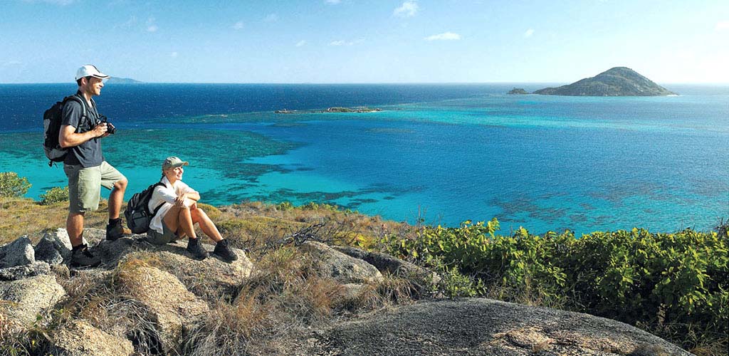
Despite issues surrounding conservation, the country offers many parks to access a wide variety of flora and fauna. Below are our recommendations for areas to visit for trekking, bird watching, and other outdoor activities. Along with these parks, we recommend you also explore nearby hilltribe areas in the north, which are threatened by similar pressures of economic expansion and dilution of their traditional cultures.
North Vietnam
Halong Bay

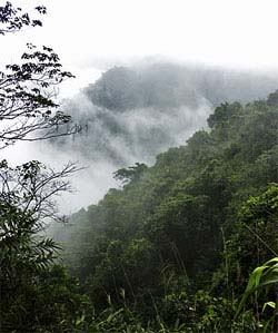
The spectacular geographic highlight of Vietnam does not disappoint, but enthralls. Halong Bay has over 3,000 limestone and dolomite islets sprinkled over an area of 1,500 square kilometers, offering a wonderland of karst topography. In recognition of this, in 1994 Halong was designated a UNESCO World Heritage Site. Legend has it that when the Vietnamese were under attack long ago, a dragon came to their aid, splitting mountains to impede the progress of the enemy. The limestone topography was created by the lash of the dragon's tail as it thundered down from the mountains to the sea; consequently, "Vinh Halong" — Halong Bay-means "Bay of the Descending Dragon." In geological terms, the mythical monster at work here is wind and water, weathering the porous limestone over a few million years. This process created the bizarre limestone cathedrals, colonized by stunted and twisted vegetation. The misty romantic setting of rugged island peaks and bays dotted with sailing junks has inspired a whole genre of Vietnamese painting. Halong Bay is featured in our 2008 Photography Series. For celluloid viewing, watch Indochine with Catherine Deneuve.
We recommend at least one night on the bay. Kayaking allows up close access to the islands and cave exploration. Read more about our trips to Halong Bay.
CAT BA ISLAND
Cat Ba Island is the largest island in the Cat Ba Archipelago, consisting of over 350 limestone outcrops adjacent to Halong Bay. Lying roughly midway between Haiphong and Hong Gai, the island falls under the administration of Haiphong City, while Halong Bay falls under the administration of Quang Ninh province. With an area of 356 square kilometers, Cat Ba encompasses forested zones, coastal mangrove and freshwater swamps, beaches, caves, and waterfalls. In 1986, the northeast side of the island was designated a national park, including a protected marine zone. Cat Ba Island supports a population of over 20,000, most of whom live off fishing or farming in the south, in and around Cat Ba Town. To confuse matters, "Cat Ba" may refer to Cat Ba Island (Dao Cat Ba), Cat Ba Town (Pho Cat Ba), Cat Ba Town Harbor (Cang Cat Ba), or indeed any part of the island. To the west of Cat Ba Island is Cat Hai Dock on Cat Hai Island.
Cat Ba Town Until the end of the 19th century, Cat Ba was home to Chinese and Vietnamese pirates, and the French maintained a customs station here. Both enterprises seem to linger-on landing or departure you may be hit with a "port tax." Experiences on Cat Ba vary. Some travelers have found the islanders friendly; others have had rocks thrown at them and midnight and in the recent past, visits from police checking documents. Nevertheless, on the Hong Gai/Bai Chay/Cat Ba triangle, it is Cat Ba that elicits the most interest. The town is small and ancient, easy to walk around, with clusters of fishing boats and inspiring sunsets across the harbor. A definite Chinese flavor remains to Cat Ba, particularly strong in the decrepit buildings on the northwest side. Chinese merchants and fisherfolk originally settled the town, but a mass exodus ensued in 1979 when hostilities broke out between the Vietnamese and Chinese. Then the tide turned somewhat as refugees were repatriated from Hong Kong holding camps. These returnees, having learned English at the Hong Kong camps, are involved with tourism on Cat Ba. The town curves around a crescent-shaped bay, with an esplanade following the foreshore. One can check out the catch of the day in the early morning, see cuttlefish dried over hot coals, or stroll around the old town. A few hours' harbor touring is worthwhile. It's a short hike from Cat Ba Town southeast over a trail and steps to sandy Cat Co Beach; there is also a tunnel leading to Cat Co Beach, now disused. From Cat Co you can hike farther along to rockier Cat Vang Beach.
Cat Ba National Park (Vuon Quoc Gia Cat Ba), near Trung Trang, lies about ten miles from Cat Ba Town and 8 miles from Phu Long. The park covers an area of about 120 square miles, of which two-thirds is a forested zone and one-third a marine zone. Park headquarters are at the small settlement of Trung Trang. The park consists mainly of inaccessible terrain, and you'll have to fight your way through thickets and up steep gullies to get anywhere. Many side trails branch off main trails in the park-mostly new forest, not old growth. On longer hikes you may see birds, including kingfishers and warblers, and perhaps a tree-dwelling possum with a long bushy tail. The park is home to rare wild white-headed langurs, which live on steep coastal cliffs. Hanoi's Biological Institute has identified over 35 species of birds, 28 species of mammal (including wild boar, macaques, and deer), 20 reptile species, and over 600 plant species within the park. The marine reserve also supports dolphins, seals, and hawksbill turtles.
Since 2000, the Cat Ba langur has been listed as one of 'The World's Top 25 Most Endangered Primates' (Conservation International and IUCN/SSC Primate Specialist Group), due to its small population and restricted range only on Cat Ba Island. In the past, poaching constituted the primary threat to the langurs' survival and resulted in a population decline from an estimated 2500-2800 individuals in the 1960s to a mere 53 individuals by 2000 (Seacology).
The designation "national park" is a misnomer considering that farming, logging, and fishing occur within park boundaries, as does poaching often involving park personnel. Cat Ba is definitely of one of the places the Vietnamese and other authorities in Asia label a national park on stray bits of land to attract tourism.
Trung Trang Caves: Two kilometers south of Trung Trang park headquarters a set of caves open into the side of a limestone cliff. The entrances to the caves are visible from the road, about 50 meters up the cliff You need a flashlight to explore the limestone caves. They are over 300 meters long, and you can easily get lost without a guide-guides are available in Cat Ba Town.
BA BE National Park (Bac Can Province)
Ba Be is a relatively easy excursion northward from Hanoi. Set aside in 1992, it is visited by tens of thousands of (mostly Vietnamese) tourists each year. The primary attraction is Ba Be Lake, the largest natural lake in Vietnam at 5 miles (8 km) long and up to 2,6oo feet (8oo m) wide. The lake is surrounded by limestone peaks and a dense evergreen forest that is fast disappearing. Numerous caves and odd karstic formations can be reached from its shores, and boat rides through one of the caves into the lake can be arranged. The total area is relatively small, only 30 square miles (7,610 ha), and the elevation ranges from 500 to 3,6oo feet (150-1,100 m). Two endemic species can be found here: Owston's Civet and Franois's Leaf Monkey. A third, the Tonkin Snub-nosed Monkey, is now extinct at this site, though it persists in neighboring Na Hang Nature Reserve. Wetland habitats support a variety of kingfishers (Families Alcedinidae and Halcyonidae), herons (Family Ardeidae), and other waterbirds and beautiful Short-billed (Pericrocotus brevirostris) and Scarlet Minivets (P. flammeus) grace the lake's shores. Butterflies are the park's best-known group. In 1997 and 1998 entomologists recorded 332, twenty-two of which were new records for Vietnam.
BA VI National Park
Ba Vi National Park is located on Mount Ba Vi about 50 km west of Hanoi. During the French colonial period, Ba Vi was developed as a hill station like Sapa and Dalat, and around 200 villas were constructed on the mountain. Similarly, it offers good opportunities for light trekking. Mount Ba Vi features three peaks — the highest is Dinh Vua at 1,296 m, followed by Tan Vien at 1,226 m and Ngoc Hoa at 1,120 m. Because of the mountainous topography, the climate at Ba Vi varies with altitude. Above 500 meters, fog enshrouds the top of the mountain on most days. Except for the Da River on the western side of the national park, Ba Vi has no large, permanent water bodies and streams in the national park are steep and fast flowing. In the rainy season, the volume of water flowing through these small watercourses and over the surface of the ground is sometimes sufficient to cause landslides. In the dry season, however, the tradeoff is many of the streams are dry and the area less picturesque.
The forest at Ba Vi National Park is an important source of forest products for local communities and there has been significant deforestation in some areas. In the park, the Dao hilltribe extract medicinal plants. With a relatively favorable climate, good infrastructure and close proximity to Hanoi, Ba Vi attracts large numbers of visitors. Travelers seeking a restorative side trip in this destination can experience Tan Da Spa Resort, located in the foot of Tan Vien Mountain. Tan Da Spa Resort is designed in the architecture of the houses of ancient Vietnamese people living in the delta of the North and features indoor and outdoor hot springs, as well as curative mud baths for individuals or families. Tourists may choose services such as therapeutic mud bath, mud bath with herbal and aromatic spices, dry and wet steam bath, and more.
CUC PHUONG (and VAN LONG RESERVE)
Cuc Phuong is Vietnam's most important area of biodiversity, designated a national park by president Ho Chi Minh in 1962. The park, roughly 6 miles wide and 15 miles long, was created in 1962-the first area in Vietnam set aside as a national park. It covers an area of 25,000 hectares, but for the moment is primarily a national park in name only. There are six Muong villages in the park: villagers farm and raise cattle on park lands and hunt. Deforestation in the surrounding area steadily encroaches on parkland, and large amounts of brushwood disappear from the park daily. The park supports a wide variety of flora species and patches of primeval forest, including 50-meter-tall Cinamomum, Parashorea, and Sandicorum trees. You can find ancient trees with thick clusters of roots, and parasitic plants and ligneous creepers. Some tree species have been introduced from Myanmar (Burma), India, and Borneo. Clusters of orchids grow near cave entrances, where the moisture conditions and light are ideal. Varieties include coral, vanilla, snow-white, and butterfly orchids.
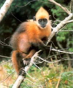
Larger mammals also inhabit the park, including panthers and bears, but hunting has severely depleted their numbers. The park supports many varieties of monkeys and gibbons. The world's last Delacourt langurs live here-an estimated 20 left in the park, and 100 in northern Vietnam. A few are kept in cages near the park gates. Other unusual mammals include a striped fox and a squirrel that glides between trees. A rare species of fish called niec hang lives in cave streams. There are over 120 species of birds and many varieties of beetles; in April and May arrive swarms of butterflies. At night, millions of cicadas create a deafening din, and millions of fireflies flicker on and off, making the place look like something out of The Hobbit. Also located within the park are the Cuc Phuong Endangered Primate Rescue Center and Cuc Phuong Turtle Conservation Center.
These facilities are vital research centers for breeding and rehabilitation of animals rescued from the illegal wildlife trade. The primate center houses specimens of langurs, loris, and gibbon species, include the critically endangered Delacour's Langur, Golden-headed Langur, Tonkin Snub-nosed Langur and Black Crested Gibbon. The primate center was established in 1993 with the help of the Frankfurt Zoological Society and has grown to 100 animals in 30 cages, 4 houses, two semi-wild enclosures. The turtle conservation center was established in 1998 and is home to some of the most endangered turtles in Vietnam, including the Vietnamese Pond Turtle which is nearly extinct in the wild.
Lying in a limestone area, Cuc Phuong includes numerous caves. At Nguoi Xua (Cave of Early Man), two ancient tombs have been discovered, along with Neolithic remains and evidence of stone implements. There have been similar finds at Trang Khuyet (Crescent Moon), Thanh Minh, and Con Moong Caves. Hang Dan Cave is known for its bat population. Hiking The best hike in the park is a six-kilometer trail starting at B-Block in the Park Center and looping back round to A-block. It's a cleared trail with steps in rough spots, slippery after rain. You hike through old-growth forest with long vines wrapped around strangled trees. Quite bizarre is Eutada tonkinensis ganep, a thick vine that shoots all over the place. You pass a Parashorea assimica tree, and halfway round the trail a large, double Terminalia miriocarpa tree stands 45 meters tall. Along the trail you also pass a small waterfall and a cave. Other notable plants include huge fern trees and the san, or tent tree, anchored in shallow soil with trunks that resemble flying buttresses. A longer hike proceeds 15 kilometers northwest from the Park Center to a Muong village, where you stay overnight. The next day you can hike four kilometers out to the roadway at the northwest side of the park, where an arranged van takes you on to Mai Chau, back to Cuc Phuong's lodges, or to Ninh Binh.
The Van Long Nature Reserve, is also located close to Cuc Phuong National Park. If making the journey to Cuc Phuong, it is recommended to stopover in Mai Chau, a river valley rich with a diverse population of hilltribes, including Black Tai, Muong, Nhang, Red Tai, and White Tai.
More Information on Cuc Phuong (opens pdf file): Birdlife International
Central Vietnam
PHONG NGA — KE BANG National Park
Located 30 miles northwest Dong Hoi and about 120 miles north of Hue, Phong Nha-Ke Bang is an over 200,000 hectares of parkland includes beautiful limestone formations, grottoes and caves as well as lush forest land covering 95 percent of the park area. It is most well known for its caves complex (below). In addition to the diversity in the ecosystem, Phong Nha-Ke Bang is home to archeological and historical relics such as an ancient hieroglyphic script of the Cham ethnic minority, Xuan Son Ferry Station, and location of the War-era Ho Chi Minh Trail. In 2000, Phong Nha-Ke Banga National Park was designated a Unesco World Heritage site.
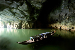
Phong Nha means "Cave of Teeth" and the cave formed approximately 250million years ago and is the largest and most interesting cave for sightseeing in the country. It contains thousands of feet of of underground passageways and river caves filled with an abundance of stalactites and stalagmites. Subterranean rock formations have lively names such as Lion, Fairy Caves, Royal Court and Buddha. During the war was used by the Northern Vietnamese as a safe haven for a hospital and ammunition depot. In 1990, British scientists surveyed 21 miles of the cave and discovered the main cavern is nearly 6 miles long with 14 other caves nearby. Boat is the primary transportation means for exploration of the cave. Note: for the distance traveled to reach Phong Nga, we recommend instead traveling to Halong Bay which also features caves complexes but is much greater in geographic breadth.
Bach Ma National Park (Thug Thien Blue Province)
Bach Ma National Park is located on a mountain ridge in central Vietnam where the country tapers to a narrow belt. The highest point in the park, Bach Ma mountain, is 1,450 meters above sea level and only 11 miles away from the coast offering panoramic views. The French also came here to escape the heat and built up a limited infrastructure. Reaching from the mountains of Laos eastward to the coast, this high ridge cuts across Vietnam's coastal plain, dividing northern and southern flora and fauna and marking the separation between two climatic zones. This location, topography, and cli-mate support a great richness of species at Bach Ma. The park, inaugurated in 1991, is characterized by dense forests studded with rhododendrons (do quyen in Vietnamese) that blossom toward the end of March, a startlingly white display amid lush greens. There is also the possibility of coming across some of the region's spectacular pheasants, such as the Gray Peacock Pheas-ant. Masked Palm Civets (Pagunra larvutir) prowl around the station bun- galows at dusk. If your traveling from Hue to Hoi An overland, this is an easy stop en route. There are also simple park cabins for accommodation.
HON MUN Marine Reserve (Nha Trang)
Nha Trang, Vietnam's most popular beach resort town, receives many scuba divers and snorkelers who can explore extensive reef systems and marine life in the clear offshore waters. Land-based visitors can also appreciate in tanks at the nearby oceanographic institute. Boating trips are also available to explore the dozens of islands off the coast. Hon Mun Island is part of a new Marine Protected Area (MPA), established in 2001, which includes several neighboring islands and surrounding waters. The MPA was established to conserve the reefs, which with more than 350 hard coral species host the richest coral diversity in Vietnam, and other marine habitats; to restore the surrounding fisheries; and to establish sustainable tourism. Fish diversity is lower than expected due to overfishing and other environmental threats, but still numbers in the hundreds of species. A few of the islands, including Hon Mun, support edible nest swiftlet (Collocalia germani) colonies, whose nests are harvested to make bird's nest soup.
South Vietnam
CAT TIEN National Park
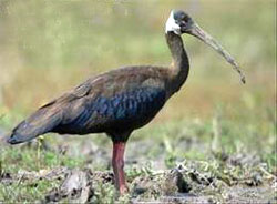
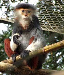
In 2002 UNESCO added Cat Tien National Park to its list of biosphere reserves. Located just over 90 miles north of Saigon (about a four-hour drive) in the provinces of Dong Nai, Lam Dong, and Phouc in Vietnam's central highlands, Cat Tien is the home to Southeast Asia's last remaining population of Lesser One-horned Rhinoceros. It is also home of known elephants within the country, concentrated only here and in Yok Don. It is also one of two locations where the White-shouldered Ibis (right) can be found. Cat Tien is also rich with a wide range of evergreen, semi deciduous and bamboo forests, and some 1,800 species of plants, including at least 62 orchid species that thrive in the park. If you are only situated in the south, then Cat Tien can be a wortwhile trip.
In Cat Tien, there are a number of wildlife excursions available. Deep in the jungle lies Crocodile Lake (Bau Sau), where the critically endangered Siamese crocodiles can be seen in the wild and the lake is home to more than 60 crocodiles that can be spotted during jeep rides, hiking or night safaris arranged by the park headquarters. Overnight accommodation at the ranger station near the lake is subject to availability. Cat Tien is also regarded as one of the best bird-watching locations in Vietnam, home to approximately 348 species, 31 of which are rare. Sought-after species such as the orange-necked partridge, Germain's peacock pheasant, Siamese fireback, green peafowl and the woolly-necked stork can be seen regularly.
The park is also home to the Dao Tien Endangered Primate Species Center, a conservation project that rehabilitates endangered golden-cheeked gibbons, black-shanked doucs, silvered langurs and pygmy lorises. The center offers educational awareness tours that elaborate on the aims of the project and the law regarding endangered wildlife in Vietnam. The Cat Tien National Park headquarters provides basic accommodation and safari tents (Forest Floor Lodges) at the. More: Cat Tien Park Official Web site.
When to go? The best time to visit Cat Tien National Park is during the dry season from October to May and avoid the hot summer (when the parks biodiversity includes an abundance of leeches that get hungry in the hot humid weather).
CON DAO National Parks
The islands of Can Dao and Phu Quoc offer some of the most pristine marine environments in Vietnam. The Con Dao Archipelago, located 50 miles southeast off the coast of Ba Ria-Vung Tau Province, is one of the most important sites in Vietnam for marine and coastal biodiversity conservation. For more than a century, until 1985, a series of governments (predominantly the French and South Vietnamese) operated an infamous penal colony housed in dismal facilities on Con Son, the largest island in the archipelago. The location is a national pilgrimage site because of the many famous political refugees who were imprisoned there. In part because of Con Dao's previous usage, the terrestrial and marine natural areas are relatively intact compared with others in Vietnam. The archipelago's sixteen islands support a diverse range of natural ecosystems, including lowland evergreen forests, coastal swamps and marshes, inland and coastal sand dunes, and seasonal freshwater streams and lakes.
Mangrove forests are found off the western coast of Con Son Island and lining Ba Island. Forests blanket more than 8o percent of the land and many of the 882 recorded vascular plant species are endemic. Several bird species seen in the archipelago have not been found anywhere else in Vietnam, including the Nicobar Pigeon (Caloenas nicobarica), Iced-billed Tropicbird (Phaethou aethereus), Pied Imperial Pigeon (Ducula bicolor), and Masked Booby (Sula dactylatra). Further inland, it is possible to catch sight of the rare Con Dao Black Giant Squirrel. The Con Dao Archipelago lies at the juncture of warm, northerly flowing and cool, southerly flowing sea currents. Both bring larval species to the islands, creating a high diversity of marine groups. Con Dao's fringing and patch coral reefs harbor large grouper (Family Serranidae) and giant clam populations and the highest recorded density of coral reef fish of am- coastal reef in Vietnam. Sea-grass beds serve as habitat for Dugongs and Green Turtles. The archipelago is important for marine turtle conservation. In 1998, five monitored beach sites yielded 500 turtle nests on Con Dao and an additional twelve to thirteen nesting beaches dot the archipelago.
PHU QUOC National Park
Phu Quoc Island, located 25 miles (4o km) off the Cau Mau Peninsula's western coast in the Gulf of Thailand, is the largest island in its archipelago. Lowland evergreen forest, the predominant vegetation on Phu Quoc, still covers much of the island. Little is known about the fauna of Phu Quoc Island. A Dugong population of unknown size has been identified from these waters, though it is clearly under great hunting pressure; at least six individuals were killed in 2002 alone. Leatherback Turtles, Loggerheads, Green Turtles, and Hawksbills have all been seen in this area. Green Turtles were formerly common, but populations are in decline owing to destruction of nest sites, collection of eggs, and over harvesting for food and shells.
Phu Quoc is also known for nuoc mam, a pungent fermented fish sauce. Nearly half the island' s population is dependent on its production. Coral reefs abound off the island, good places for diving and snorkeling, offer a chance to see beautiful tropical fish and other marine life. For nearly a decade, Phu Quoc has been of significant interest to resort developers and the government is beginning to take initial steps for formal development agreements, including the completion of a new airport. The island has the potential to rival popular destinations in the region such as Phuket and Krabi.
CAN GIO Biosphere Reserve
Can Gio Biosphere Reserve is a wetland located 40 km southeast of Ho Chi Minh City on the coast. Historically, this land had been damaged by toxic chemicals that turned the zone into an uninhabited land. The forest has gradually recovered and the site is now an important wildlife sanctuary and has been listed the biosphere reserve by UNESCO. It is characterized by a wetland biosystem dominated by mangrove and may rare species, including home to a large number of egrets, storks, pelicans and other aquatic birds, as well as to Long-tailed Macaques (Macaca fascicularis — right). The mudflats and sandbanks there are important habitats for migrating shorebirds.The forest's area covers 75,740 ha, with over 150 botanical species. From My Tho, located on one of the Mekong's branches in Ben Tre Province, one can take a boat trip downstream into the coastal mangrove belt, which extends 220 miles (350 km) southward to the tip of Ca Mau Province.
Bird Species, click for more information: Birdlife International