
Divining Angkor
After rising to sublime heights, the sacred city may have engineered its own downfall
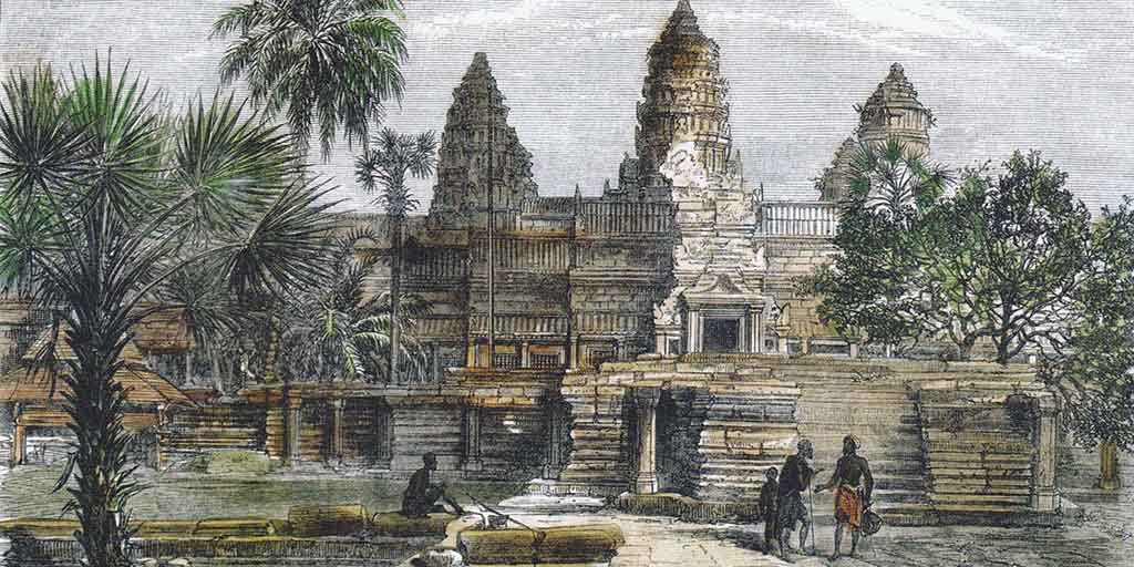
From the air, the centuries-old temple appears and vanishes like a hallucination. At first it is no more than an umber smudge in the forest canopy of northern Cambodia. Beneath us sprawls the lost city of Angkor, now in ruins and populated mostly by peasant rice farmers. Clusters of Khmer homes, perched on spindly stilts to cope with flooding during the summer monsoon, dot the landscape from the Tonle Sap, the "great lake" of Southeast Asia, some 20 miles to the south, to the Kulen Hills, a ridge jutting from the floodplain a roughly equal distance to the north. Then, as Donald Cooney guides the ultralight plane over the treetops, the magnificent temple comes into view.
Restored in the 1940s, the 12th-century Banteay Samre, devoted to the Hindu god Vishnu, recalls the medieval Khmer Empire at its height. The temple is cloistered inside two sets of concentric square walls. These may once have been surrounded by a moat symbolizing the oceans encircling Mount Meru, mythical home of Hindu gods. Banteay Samre is just one of more than a thousand shrines the Khmer erected in the city of Angkor during a building spree whose scale and ambition rivals the pyramids of Egypt. After we pass, I crane my neck for a last look. The temple has disappeared into the forest.

Angkor is the scene of one of the greatest vanishing acts of all time. The Khmer kingdom lasted from the ninth to the 15th centuries, and at its height dominated a wide swath of Southeast Asia, from Myanmar (Burma) in the west to Vietnam in the east. As many as 750,000 people lived in Angkor, its capital, which sprawled across an area the size of New York City's five boroughs, making it the most extensive urban complex of the preindustrial world. By the late 16th century, when Portuguese missionaries came upon the lotus-shaped towers of Angkor Wat—the most elaborate of the city's temples and the world's largest religious monument—the once resplendent capital of the empire was in its death throes.
Scholars have come up with a long list of suspected causes, including rapacious invaders, a religious change of heart, and a shift to maritime trade that condemned an inland city. It's mostly guesswork: Roughly 1,300 inscriptions survive on temple doorjambs and freestanding stelae, but the people of Angkor left not a single word explaining their kingdom's collapse.
Recent excavations, not of the temples but of the infrastructure that made the vast city possible, are converging on a new answer. Angkor, it appears, was doomed by the very ingenuity that transformed a collection of minor fiefdoms into an empire. The civilization learned how to tame Southeast Asia's seasonal deluges, then faded as its control of water, the most vital of resources, slipped away.
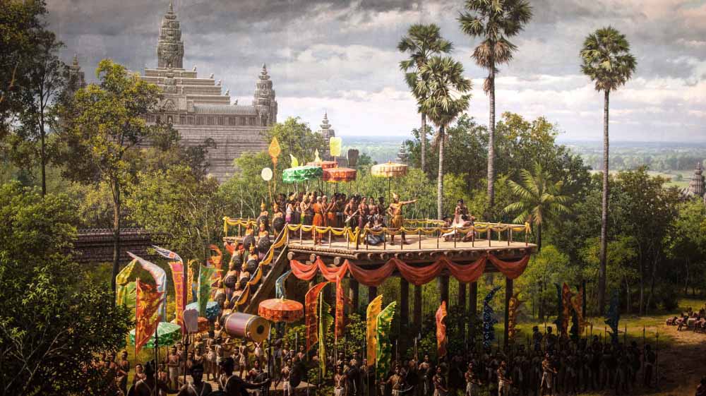
An intriguing firsthand account brings the city to life at its zenith. Zhou Daguan, a Chinese diplomat, spent nearly a year in the capital at the end of the 13th century. He lived modestly as a guest of a middle-class family who ate rice using coconut-husk spoons and drank wine made from honey, leaves, or rice. He described a gruesome practice, abandoned not long before his visit, that involved collecting human gall from living donors as a tonic for courage. Religious festivals featured fireworks and boar fighting. The greatest spectacles occurred when the king ventured out among his subjects. Royal processions included elephants and horses decorated with gold, and hundreds of palace women bedecked in flowers.
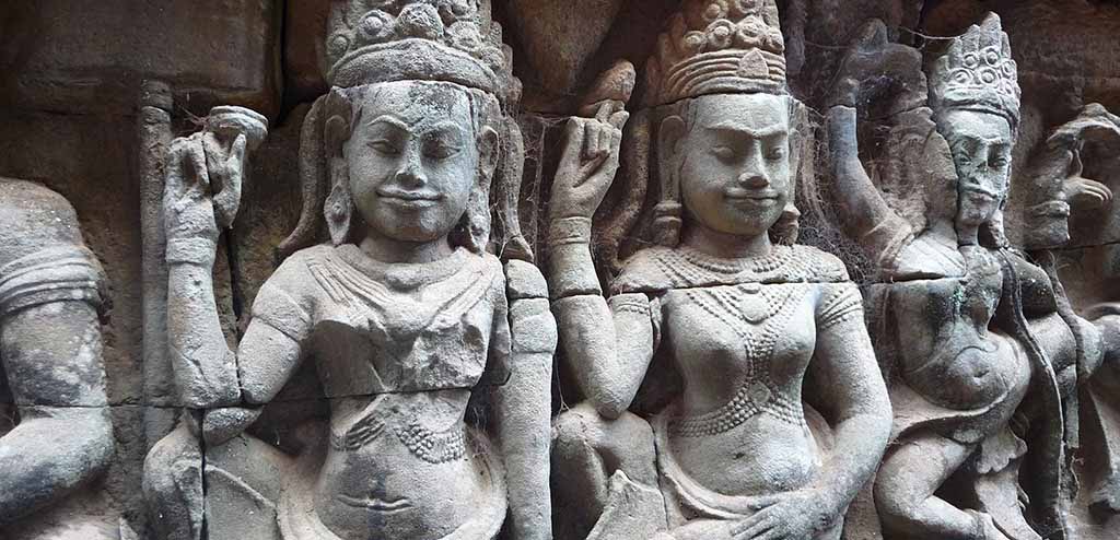
Angkor's daily rhythms also come to life in sculptures that have survived centuries of decay and, more recently, war. Bas-reliefs on temple facades depict everyday scenes—two men hunched over a board game, for instance, and a woman giving birth under a shaded pavilion—and pay homage to the spiritual world inhabited by creatures such as apsaras, alluring celestial dancers who served as messengers between humans and the gods.
The bas-reliefs also reveal trouble in paradise. Interspersed with visions of earthly harmony and sublime enlightenment are scenes of war. In one bas-relief, spear-bearing warriors from the neighboring kingdom of Champa are packed stem to stern in a boat crossing the Tonle Sap. The scene is immortalized in stone, of course, because the Khmer were successful in battle.
Although Angkor won that clash, the city was riven by rivalry, which heightened its vulnerability to attacks from Champa to the east and the formidable kingdom of Ayutthaya to the west. Khmer kings had several wives, which blurred the line of succession and resulted in constant intrigue as princes vied for power. "For centuries, it was like the Wars of the Roses. The Khmer state was often unstable," says Roland Fletcher, an archaeologist at the University of Sydney and co-director of a research effort called the Greater Angkor Project.
Some scholars believe that Angkor died the way it lived: by the sword. The annals of Ayutthaya state that warriors from that kingdom "took" Angkor in 1431. No doubt the prosperous Khmer city would have been a rich prize: Inscriptions boast that its temple towers were clad in gold, as Zhou's breathless account confirms. To reconcile tales of Angkor's wealth with the dilapidated ruins encountered by Western travelers, French historians a century ago concluded from the tantalizing allusion that Ayutthaya sacked Angkor.
Fletcher, who says his obsession is to "figure out what makes settlements grow and die," is dubious. Some early scholars, he says, viewed Angkor through the lens of the sieges and conquests of European history. "The ruler of Ayutthaya, indeed, says he took Angkor, and he may have taken some formal regalia back to Ayutthaya with him," says Fletcher. But after Angkor was captured, Ayutthaya's ruler installed his son on the throne. "He's not likely to have smashed the place up before giving it to his son."
Court intrigue may not have perturbed most of Angkor's subjects, but religion was central to daily life. Angkor was what anthropologists call a regal-ritual city. Its kings claimed to be the world emperors of Hindu lore and erected temples to themselves. But as Theravada Buddhism gradually eclipsed Hinduism in the 13th and 14th centuries, its tenet of social equality may have threatened Angkor's elite. "It was very subversive, just like Christianity was subversive to the Roman Empire," says Fletcher. "It would have been exceedingly difficult to stop."
Such a religious shift would have eroded royal authority. The regal-ritual city operated on a moneyless economy, relying on tribute and taxation. The kingdom's de facto currency was rice, staple of the conscripted laborers who built the temples and the cast of thousands who ran them. An inscription at one complex, Ta Prohm, notes that 12,640 people serviced that temple alone. The inscription also records that more than 66,000 farmers produced nearly 3,000 tons of rice a year to feed this multitude of priests, dancers, and temple workers. Add just three large temples to the equation—Preah Khan and the larger complexes of Angkor Wat and the Bayon—and the calculated farm labor required swells to 300,000. That's nearly half of the estimated population of Greater Angkor. A new, egalitarian religion such as Theravada Buddhism might have led to rebellion.
Or maybe the royal court simply turned its back on Angkor. Successive rulers had a habit of erecting new temple complexes and letting older ones decay, and that penchant for starting anew might have doomed the city when sea trade began to flourish between Southeast Asia and China. Maybe it was simple economic opportunism that, by the 16th century, had caused the Khmer center of power to shift to a location closer to the Mekong River, near Cambodia's present-day capital, Phnom Penh, affording it easier access to the South China Sea.
Economic and religious turmoil may have hastened Angkor's downfall, but its rulers were blindsided by another foe. Angkor became a medieval powerhouse thanks to a sophisticated system of canals and reservoirs that enabled the city to hoard scarce water in dry months and disperse excess water during the rainy season. Forces beyond Angkor's control threw this exquisitely tuned machine into disarray.
One of Angkor's holiest sites is high in the Kulen Hills at the headwaters of two rivers, the Puok and the Siem Reap. Under the shade of gnarled strangler fig trees, submerged in the clear water of a lazy creek, are row after row of circular bumps, each about six inches wide, carved into the dark sandstone riverbed. These are worn lingams, cylindrical stone sculptures representing the essence of the Hindu god Shiva. The lingams lead like a road to another sculpture in the riverbed: a thick-walled square, a yard wide, with a narrow inlet. It's a yoni, a symbol of the Hindu source of life.
Angkor's high priests came here to thank the gods for providing the lifeblood of the kingdom. A short walk upstream is a natural bridge of sandstone that lends this holy site its name, Kbal Spean—Khmer for "bridgehead." Water rushes through a cleft, splashing an adjoining rock face where Vishnu, legs crossed, meditates atop an angry ocean; sprouting from his navel is a lotus-flower-bearing Brahma. Here in the Kulen Hills the ancient gods enjoy perpetual libations from flowing water.
By harnessing the monsoon tide that gushed from the Kulen Hills, Angkor and its rulers flourished. From the era of Jayavarman II, who laid the kingdom's foundations in the early 800s, the empire's growth depended on bumper rice harvests. Throughout southern Asia, perhaps only the ancient cities of Anuradhapura and Polonnaruwa in Sri Lanka and their famed reservoirs could compare to Angkor's ability to guarantee a steady water supply.
That reliability required massive feats of engineering, including a reservoir called the West Baray that's five miles long and 1.5 miles wide. To build this third and most sophisticated of Angkor's large reservoirs a thousand years ago, as many as 200,000 Khmer workers may have been needed to pile up nearly 16 million cubic yards of soil in embankments 300 feet wide and three stories tall. To this day the rectangular reservoir, orbaray, is fed by water diverted from the Siem Reap River.
The first scholar to appreciate the scale of Angkor's waterworks was Bernard-Philippe Groslier, an archaeologist with the French School of Asian Studies (EFEO). In a landmark 1979 treatise, he envisioned Angkor as a "hydraulic city." The great barays, he argued, served two purposes: to symbolize the primeval sea of Hindu cosmogony and to irrigate rice fields. Unfortunately, Groslier could not pursue this concept further. Cambodia's civil war, the brutal reign of the Khmer Rouge, and the ouster of the regime by Vietnamese forces in 1979 turned Angkor into a no-go zone for two decades. After Vietnamese troops withdrew, looters descended on Angkor, swiping statues and even chiseling off bas-reliefs.
When Christophe Pottier, an architect and archaeologist, reopened EFEO's research station at Angkor in 1992, the first priority was helping Cambodia restore dilapidated and pillaged temples. But Pottier was drawn to the wilderness beyond the temple walls. He spent months crisscrossing the southern half of Greater Angkor on motorbike and foot, mapping once hidden house mounds and shrines near artificial ponds called water tanks. (Lingering lawlessness deterred Pottier from surveying the northern half.) Then, in 2000, Fletcher and his colleague Damian Evans laid hands on NASA radar images of Angkor. They were a revelation: The University of Sydney team, working with EFEO and APSARA, the Cambodian agency that manages Angkor, found vestiges of many more settlements, canals, and water tanks, particularly in Angkor's inaccessible areas. Donald Cooney's ultralight flights have helped Fletcher and Pottier, now a co-director of the Greater Angkor Project, examine these features in finer detail. Crucially, they found inlets and outlets to the barays, ending a debate catalyzed by Groslier's work about whether the colossal reservoirs were used solely for religious rituals or for irrigation. The clear answer is both.
The researchers were amazed by the ambition of Angkor's engineers. "We realized that the entire landscape of Greater Angkor is artificial," Fletcher says. Over several centuries, teams of laborers constructed hundreds of miles of canals and dikes that relied on subtle differences in the land's natural inclination to divert water from the Puok, Roluos, and Siem Reap Rivers to the barays. During the summer monsoon months, overflow channels bled off excess water. After the rains petered out in October or November, irrigation channels dispensed stored water. The barays may also have helped replenish soil moisture by allowing water to soak into the earth. In surrounding fields surface evaporation would have drawn up the groundwater to supply crops. "It was an incredibly clever system," says Fletcher.
That clever water system may have made the difference between mediocrity and greatness. Much of the kingdom's rice was grown in embanked fields that would otherwise have relied on monsoon rains or the seasonal ebb and flow of water on the Tonle Sap floodplain. Irrigation would have boosted harvests. The system could also have provided survival rations during a poor monsoon season, says Fletcher. And the ability to divert and impound water would have afforded a measure of protection from floods. When other kingdoms in Southeast Asia were struggling to cope with too little or too much water, he says, Angkor's waterworks would have been "a profoundly valuable strategic asset."
Thus Fletcher was baffled when his team unearthed one of the more extraordinary pieces of Angkorian workmanship—a vast structure in the waterworks—and found that it had been demolished, apparently by Angkor's own engineers.
It's almost noon on a June day about ten miles north of Angkor Wat, and even at the bottom of a muddy, 14-foot-long trench, there's no relief from the fierce sun. Fletcher takes off a dark blue baseball cap and wipes his brow. It looks as if the self-possessed researcher is going to launch into a precise explanation of the grayish red stone blocks his team, along with Chhay Rachna of APSARA, has unearthed. Instead, he sighs and says, "This is simply fantastic!"
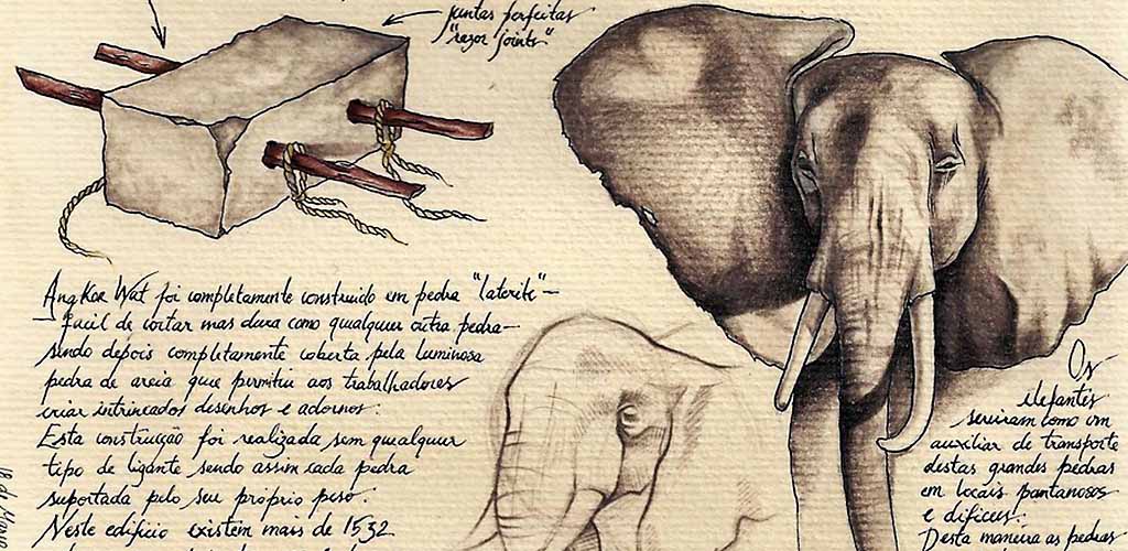
The stone blocks fitting snugly together were hewed from laterite, a spongy, iron-laden soil that hardens when exposed to air. When Fletcher and Pottier first found a section of the structure a few years ago, they thought it was the remains of a small sluice gate.

"It's turned into a monster," he says. The blocks are the remnants of a spillway across a sloping dam that may have extended as long as a football field. Around the end of the ninth century, with Angkor blossoming, engineers excavated a long canal that altered the course of the Siem Reap River, redirecting it southward to the newly constructed East Baray, a reservoir nearly as big as the later West Baray. The dam, positioned in the river, diverted water to feed the canal. But part of the massive structure may also have functioned as a spillway during monsoon surges, when water would have overtopped the low structure and flowed down the former river channel.
The ruins of the spillway are a vital clue to an epic struggle that unfolded as generations of Khmer engineers coped with a water system that grew ever more complex and unruly. "They probably spent vast portions of their lives fixing it," says Fletcher. Some of the dam's blocks lie in a jumble; huge sections of masonry are missing. "The most logical explanation is that the dam failed," Fletcher says. The river may have chewed into the dam, gradually weakening it. Perhaps it was washed away by an unusually heavy flood, the kind that comes along every century or even every 500 years. The Khmer then ripped apart much of the remaining stonework, salvaging the blocks for other purposes.
Another clue that the water system was failing comes from a pond at the West Mebon, an island temple in the middle of the West Baray. Pollen grains preserved in the muck show that lotuses and other aquatic plants flourished in the baray until the early 13th century. Then new kinds of pollen appear, from species such as ferns that prefer marsh or dry land. Right at Angkor's zenith, one of its reservoirs apparently went dry for a time. "Something was going wrong much earlier than we expected," says Daniel Penny, a pollen expert and a co-director of the Greater Angkor Project.
Any deterioration of the waterworks would have left Angkor vulnerable to a natural phenomenon no engineer of that day could have anticipated. Starting in the 1300s, Europe endured a few centuries of unpredictable weather marked by harsh winters and chilly summers. Until recently there was only sketchy information on how other parts of the world fared during this period, called the Little Ice Age. Now it appears that Southeast Asia, too, experienced climatic upheaval.
Around Angkor, the summer monsoon season lasts from roughly May through October and delivers nearly 90 percent of the region's yearly precipitation. A dependable monsoon is critical for all manner of life, including people. To unmask monsoon patterns of long ago, Brendan Buckley of the Lamont-Doherty Earth Observatory in Palisades, New York, ventured into the forests of Southeast Asia in search of trees with annual growth rings. He and his team knew it would not be easy: Most species in the region lack distinguishable growth rings or have ones that aren't laid down year by year. Several forays paid off with a clutch of long-lived species, including teak and po mu, a rare cypress. Some po mu trees they cataloged are nine centuries old, survivors of both Angkor's heyday and its demise.
The po mu trees told a stunning story. Sets of constricted growth rings showed that the trees had endured back-to-back mega-droughts, from 1362 to 1392 and from 1415 to 1440. During these periods the monsoon was weak or delayed, and in some years it may have failed completely. In other years, megamonsoons lashed the region.
To a tottering kingdom, extreme weather could have been the coup de grâce. Decades earlier, Angkor's waterworks were already ailing, to judge from the idled West Baray. "We don't know why the water system was operating below capacity—it's a conundrum," says Penny. "But what it means is that Angkor really had no fat to burn. The city was more exposed to the threat of drought than at any other time in its history." Prolonged and severe droughts, punctuated by torrential downpours, "would have ruined the water system," says Fletcher.
Still, Penny says, "we're not talking about the place becoming a desert." People on the Tonle Sap floodplain south of the main temples would have been buffered from the worst effects. The Tonle Sap is fed by the Mekong River, whose headwaters in Tibetan glacier fields would have been largely immune to the effects of an altered monsoon. But Khmer engineers, skilled as they were, could not alleviate parched conditions in the north by moving Tonle Sap water against the lay of the land. Gravity was their only pump.
If inhabitants of northern Angkor were starving while other parts of the city were hoarding rice, the stage would have been set for severe unrest. "When populations in tropical countries exceed the carrying capacity of the land, real trouble begins," says Yale University anthropologist Michael Coe. "This inevitably leads to cultural collapse." A malnourished army, preoccupied with internal strife, would have exposed the city to attack. Indeed, Ayutthaya's invasion and the Khmer king's ouster happened near the end of the second megadrought.
Add to the climate chaos the shifting political and religious winds already buffeting the kingdom, and Angkor's fate was sealed, says Fletcher. "The world around Angkor was changing. Society was moving on. It would have been a surprise if Angkor persisted."
The Khmer Empire was not the first civilization felled by climate catastrophe. Centuries earlier, as Angkor was rising, halfway around the world a similar loss of environmental equilibrium was hammering the Maya city-states in Mexico and Central America. Many scholars now believe that the Maya succumbed to overpopulation and environmental degradation following a series of three punishing droughts in the ninth century. "Essentially, the same thing happened to Angkor," says Coe, who in the 1950s was the first to discern similarities between the Khmer and Maya civilizations.
Modern societies may need to brace for similar climatic challenges. According to Buckley, the most likely trigger of the Angkor megadroughts was intense and persistent El Niño warming of the surface waters of the central and eastern tropical Pacific Ocean. Scientists debate whether human-caused climate change will lead to more pronounced El Niños, but the Vietnamese tree rings show that even natural oscillations in the Pacific can spark catastrophe.
Angkor's end is a sobering lesson in the limits of human ingenuity. The Khmer had transformed their world—a monumental investment that would have been excruciating for the kingdom's rulers to forsake. "Angkor's hydraulic system was an amazing machine, a wonderful mechanism for regulating the world," Fletcher says. Its engineers managed to keep the civilization's signal achievement running for six centuries—until, in the end, a greater force overwhelmed them.
Further reading: The Fall of the Khmer Empire - What Caused Angkor's Collapse?